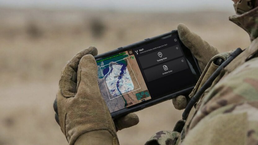
WASHINGTON — U.S. Special Operations Command is evaluating a mobile software platform that would allow operators in the field to access commercial satellite imagery and imagery analytics directly on handheld Android tactical devices.
The platform, developed by Austin-based geospatial data company SkyFi, integrates with ATAK devices — short for Android Tactical Assault Kit. These are ruggedized smartphones and tablets used by military and law enforcement units for battlefield awareness, mapping and mission coordination.
SkyFi chief executive Luke Fischer said the rapid expansion of commercial Earth-observation satellites is reshaping how military users consume intelligence. Instead of relying solely on imagery processed and distributed through centralized analysis centers, operators want direct access to satellite data on mobile devices during missions.
Fischer, a former U.S. special operations aviator, said SkyFi developed the software specifically for military users who are seeking better access to imagery and AI-enabled analytics “at the tactical edge,” military terminology referring to forces operating in dispersed or communications-constrained environments.
The company received a contract of undisclosed value to develop the software and an ATAK plugin, and conduct exploratory field tests with SOCOM operators.
An ecosystem of defense contractors and software firms has emerged around the ATAK platform, building plugins and data services that extend its capabilities. Users can access maps, friendly force locations, drone feeds, sensor data and operational information into a single mobile interface.
SkyFi is looking to bring commercial satellite imagery into that environment.
The company operates what it describes as an Earth intelligence marketplace, aggregating imagery and analytics from dozens of commercial imaging constellations rather than owning satellites directly. Its platform combines optical imagery, synthetic aperture radar, hyperspectral data and analytics from multiple providers.
Commercial satellite constellations now generate vastly more imagery, while improvements in cloud computing and mobile software have raised expectations that intelligence products should be available directly to operators in the field.
Otherwise, military personnel needing satellite imagery have to submit requests ahead of operations through centralized channels, with limited ability to directly retrieve or task imagery once deployed. In denied or degraded communications environments, access becomes even harder.
The SkyFi software allows users to pull archived imagery, request new collections and integrate remotely sensed data into operational workflows, Fischer said. Some functions — including directly tasking satellites — still depend on cloud connectivity.
“Before going out on a mission, a soldier can upload the most relevant information on where they are fighting or training,” Fischer said. Once in the field, operators can request archived imagery and apply analytics tools if communications are available.
Bandwidth management is a central challenge. Rather than pushing large volumes of imagery to deployed forces, the idea is to deliver highly localized data sets tied to a user’s operational area.
“If you’re fighting in X country, you don’t need imagery of the whole country,” Fischer said. “You need to know what your lane is.”
He said the company has tested similar direct-to-device imagery systems with military units outside the United States for more than a year.
The concept also has potential applications beyond the military. Fischer said SkyFi is marketing similar capabilities to civilian agencies and emergency-response organizations that already use ATAK devices, including law enforcement, firefighting and forestry services.
“There’s over 500,000 users of ATAK devices” across those communities, Fischer said.
Former Uber engineers helped develop the SkyFi application, Fischer added. “Everything points to getting information to the edge.”