SAN FRANCISCO – The first global dataset showing the boundaries of agricultural fields was released in late April, after an 18-month campaign by geospatial experts in industry and academia.
The initiative, led by the nonprofit Taylor Geospatial and Microsoft AI for Good Lab, produced an open and publicly available dataset with applications for food security, carbon accounting, precision agriculture and water-quality analysis.
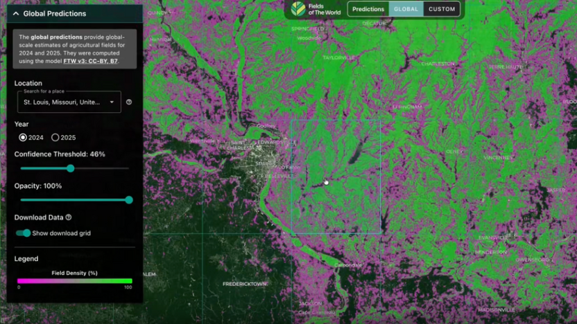
The Fields of the World project also revealed the challenges of applying machine learning and computer vision to satellite data “to get insights at global scale,” Jennifer Marcus, Taylor Geospatial vice president of strategic innovation programs told SpaceNews.
Taylor Geospatial was established in St. Louis in 2025 to catalyze the development and commercialization of geospatial AI.
“Our focus is on the application of AI, machine learning and computer vision to satellite imagery with the ambitious goal of being able to create global datasets and publish the training data, models and output data,” Marcus said.
Despite rapid progress in applying AI to language and photographs of everyday objects, hurdles remain in applying it to satellite imagery. The Fields of the World project began by bringing together geospatial experts in industry and academia to create a training dataset.
“Part of the limitation in our industry is that training data can be very focused on just the U.S. or just European countries, where the governments put out data that could be used as ground truth,” Marcus said. “We took it upon ourselves to create a more global training dataset.”
Next, participants selected the best model architecture and published their results. The global dataset was then released with a confidence layer, showing “the model works better in some places than others,” Marcus said.
Features of the World
Other global datasets could be created in a similar fashion.
“We proved the people part of this,” Marcus said. “No one organization can do this. It requires the modeling and machine-learning community” plus infrastructure and access to extensive graphics processing.
A future Taylor Geospatial project called Features of the World will look at infrastructure that can be mapped at global scale.
As for the Fields of the World, the United Nations Food and Agriculture organization and NASA Harvest, a group that encourages adoption of Earth-observation imagery for food supply and agricultural production, are applying the dataset.
“We’re moving into the phase of stakeholder engagement, where we see how people might use it and make fixes,” Marcus said. “Those local fixes will have a feedback loop into the model and the training data to continuously improve output from the model.”