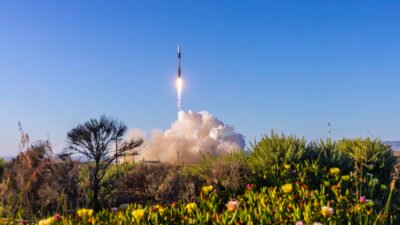
KRAKOW — Four OroraTech satellites that are part of the Hellenic Fire System launched and deployed on May 3, the Munich-based company announced.
The mission makes Greece the first country to deploy a sovereign operational constellation dedicated specifically to wildfire detection.
The satellites, named Forest-16, 17, 18 and 19, were launched from a SpaceX Falcon 9 rocket from Vandenberg Space Force Base in California on May 3 and successfully deployed between 11:19 and 11:21 am CEST into a 590-kilometer sun-synchronous orbit.
Developed for the Greek Ministry of Digital Governance and Artificial Intelligence and the Hellenic Space Center together with the European Space Agency, the system will provide continuous, near real-time wildfire intelligence across 100% of Greek territory.
“Today marks a major step forward in strengthening Greece’s national resilience against wildfires,” said Dimitris Papastergiou, minister of digital governance and artificial intelligence. “By integrating space-based capabilities into our emergency response systems, we are equipping our fire services with the tools they need to respond faster and act more effectively.”
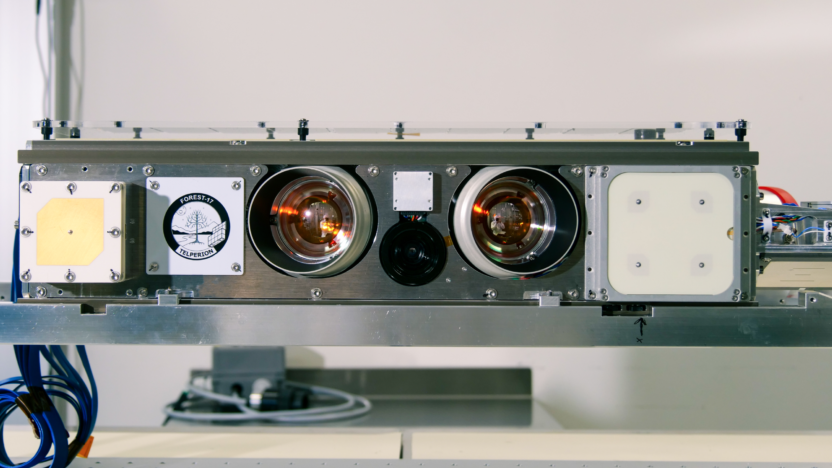
The system consists of four proprietary OroraTech Forest satellites equipped with advanced thermal infrared cameras, a ground station based in Greece, and OroraTech’s Wildfire Solution platform integrated into the country’s emergency services programs. The German startup has been responsible for the entire system, from satellite manufacturing to final data processing.
“For the first time, an entire country is protected by a dedicated satellite constellation built to detect and track wildfires in real time,” Martin Langer, CEO of OroraTech, said after the launch.
Both the United States and Europe have long operated wildfire detection systems from space through missions such as MODIS, NOAA’s GOES and Copernicus. However, this is the first time a European national sovereign constellation has been dedicated exclusively to wildfire detection.
MODIS and Copernicus provide global coverage, but their revisit time typically ranges from about 12 hours to two days depending on latitude and sensor configuration, with spatial resolutions between roughly 250 meters and 1 kilometer. GOES-18 provides observations as frequently as every five minutes over the continental United States. Data from the OroraTech constellation will enable near real-time detection of fires with a latency of one to two minutes for on-board processing, and the ability to identify hotspots as small as four by four meters across all Greek territory.
The system has been developed with contribution from the European Space Agency, which provided technical assistance to the Greek government and managed the tender with industry.
“Constellations like the OroraTech ones are complementary to Copernicus,” Simonetta Cheli, ESA’s director of Earth observation programs, told SpaceNews. “They contribute as Copernicus contributing missions and complement [Copernicus] with more localized and higher-resolution data over specific areas.”
Data such as the one provided by OroraTech, Cheli added, could therefore potentially be considered, after commissioning, within the data-buy package in the context of Copernicus Contributing Missions.
The satellites in the next few weeks will be prepared for full-time use by the Greek emergency services. The constellation is expected to become fully operational in the coming months.