

Across Europe, border environments are becoming increasingly dynamic and complex. Activity can shift within hours—vehicles reposition, staging areas disperse, small watercraft alter routes, and nodes of activity appear and disappear with little warning.
For national security organizations, ministries of interior, and supporting non-governmental partners, the challenge in border monitoring is no longer access to information alone. It is tempo. The ability to observe, understand, and respond before conditions change is a defining advantage.
Commercial space-based intelligence providers, including BlackSky, are reshaping how governments monitor border environments by delivering high-frequency imagery combined with AI-enabled analytics. The value is not simply observing a location from orbit; it is the compression of the decision cycle.
Tactical clarity at the point of activity
At the tactical level, border security agencies must answer a simple but urgent question: what is happening right now?
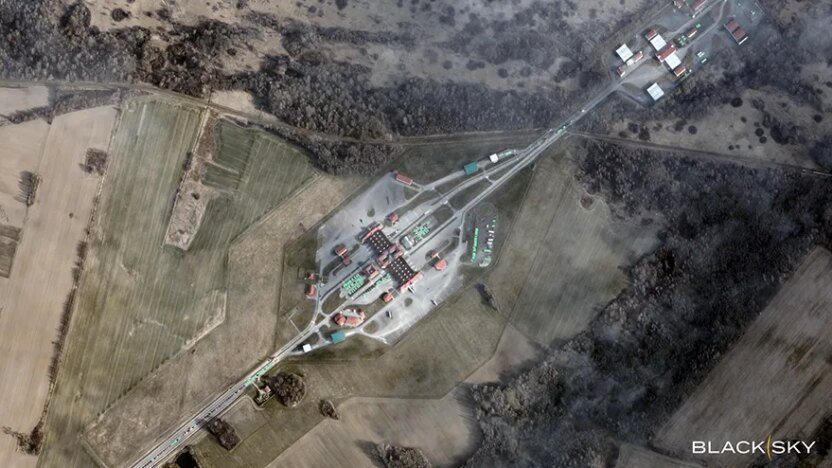
Persistent satellite monitoring enables detection of objects and activity that indicate emerging crossings or organized facilitation networks. This includes concentrations of vehicles near non-transit corridors, temporary encampments or staging areas, aircraft operating in support roles, or small maritime vessels maneuvering outside established traffic patterns.
High-frequency revisit rates and rapid intelligence delivery are critical. Border zones—whether land corridors, coastal approaches, or island chains—are fluid. While a single image may confirm activity, persistent coverage reveals whether that activity is building, dispersing, or shifting.
AI-enabled analytics enhance this process by automatically detecting and classifying vehicles, vessels, and aircraft, allowing analysts to focus on anomalies rather than manually scanning imagery. Instead of relying solely on patrol reports or delayed intelligence summaries, tactical commanders gain near real-time insight into emerging activity.

The result is practical: assets can be deployed based on current conditions rather than yesterday’s assessment. In border environments, where change is frequent and organized networks are adaptive, speed at the tactical level directly supports deterrence and disruption.
Coordinated response across the border zone
While tactical awareness reveals what is happening now, operational leadership must determine how to allocate resources across sectors, regions, and missions over time.

Persistent monitoring supports the development of pattern-of-life analysis across weeks and months. Where are vehicle concentrations increasing? Which maritime approaches are experiencing sustained pressure? Are staging areas moving, and if so, are shifts occurring in predictable cycles?
By identifying emerging pressure points early, agencies can reposition assets before an area becomes overwhelmed. Rather than reacting to incidents, commanders can manage broader border environments proactively.
Speed in this context is not just rapid imagery delivery; it is shortening the time between intelligence analysis and resource reallocation. High-cadence space-based monitoring allows planners to see shifts as they develop, reducing reliance on fragmented reporting streams and improving coordination across ministries and partner agencies.
Anticipating and shaping long-term posture
At the strategic level, border security is about reducing uncertainty.
Sustained monitoring over time can reveal the development of logistics nodes, recurring transportation patterns, infrastructure supporting facilitation networks, and persistent staging behavior across regions.
These indicators may not signal immediate incidents, but they inform broader assessments about how routes evolve and how networks adapt. This perspective supports more informed decisions on posture, investment, and cross-border coordination.
Early visibility into these patterns allows policymakers to anticipate rather than merely respond. Speed at the strategic level becomes a matter of decision advantage: the faster indicators are identified, confirmed, and contextualized, the more effectively governments can shape their posture diplomatically, operationally, or through resource prioritization.

From awareness to advantage
European border environments are no longer static lines to be monitored intermittently. They are dynamic systems influenced by mobility, organization, and rapid adaptation.
Commercial space-based intelligence has matured to the point where persistent high-frequency monitoring is not only possible, but operationally actionable. When combined with AI-enabled object detection and analytics, satellite imagery provides more than situational awareness; it’s a tool for accelerating decisions.
BlackSky’s high-frequency, low-latency satellite constellation and analytics platform are designed for precisely this tempo-driven environment. By delivering frequent revisits—ranging from daily to hourly—automated detection of objects of tactical interest, and rapid tasking capabilities, BlackSky enables governments to monitor evolving border conditions and coordinate responses at the speed modern security demands.
In an environment where activity shifts quickly, speed is not simply a technical attribute. It is a strategic necessity.
Request a demo to see how space-based intelligence provides rapid situational awareness on border activity. Start a conversation.