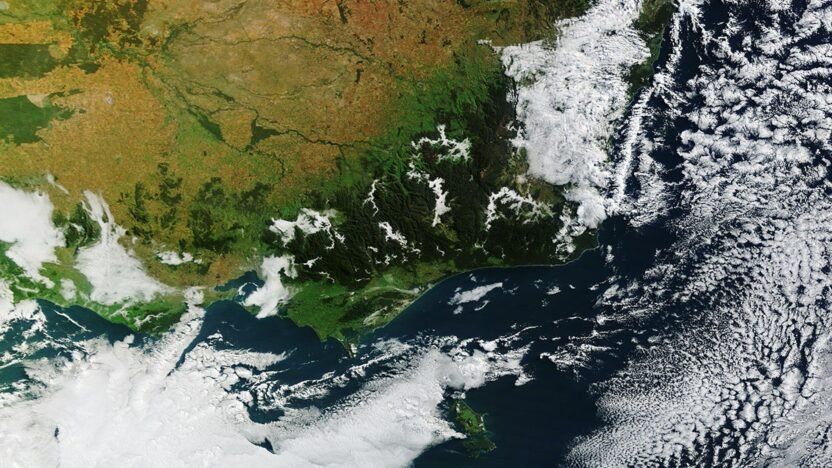
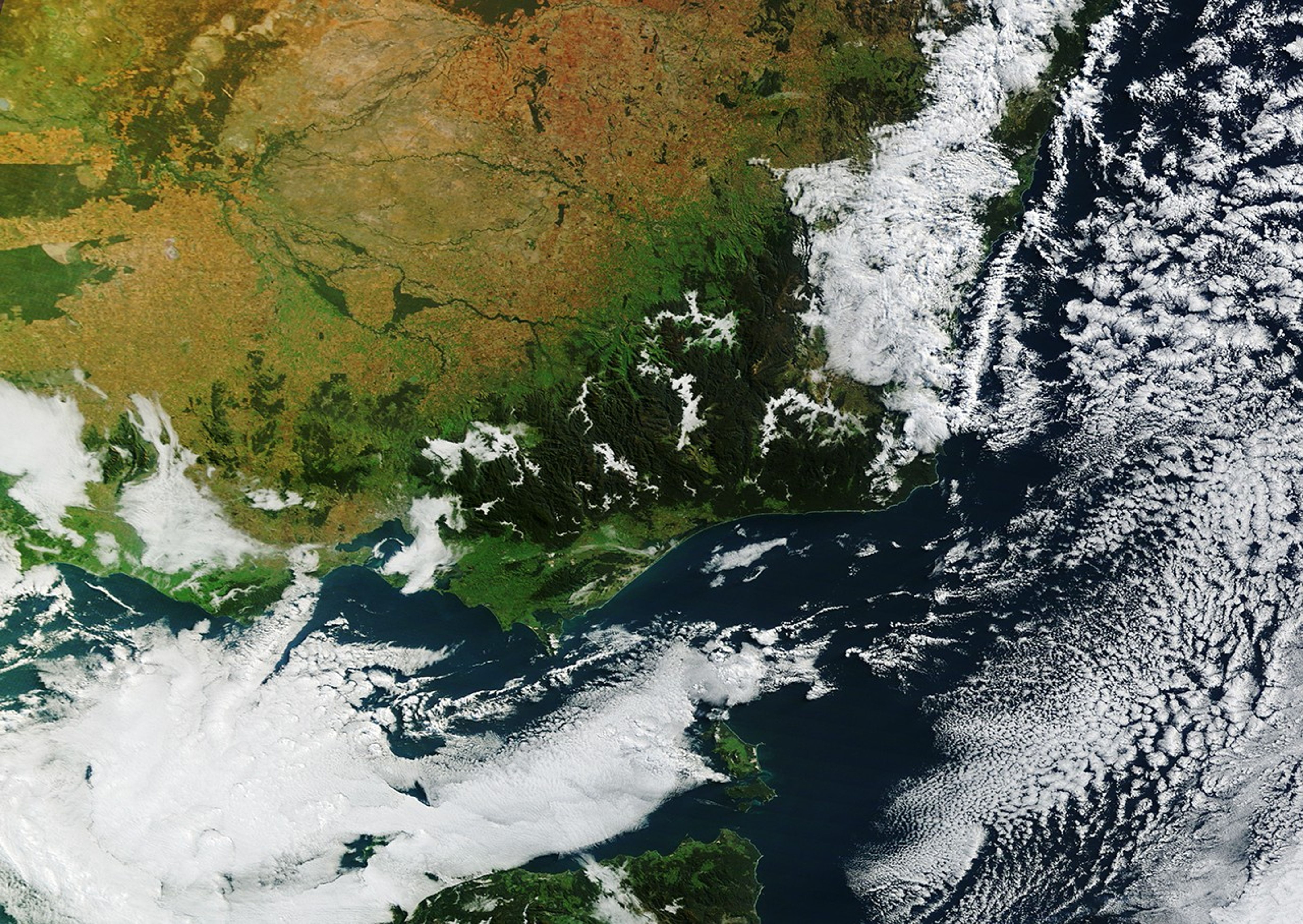
It’s autumn in the Southern Hemisphere, which means it’s fog season in the Victorian Alps. NASA’s Terra satellite captured this view of morning fog filling valleys in several national parks across the mountains of eastern Victoria in May.
As nights lengthen with the season, the atmosphere has more time to cool and approach the dew point—the temperature at which the air becomes saturated and water vapor can condense into radiation fog. Because cold air is denser than warm air, it sinks and drains into valleys, allowing fog to develop there first. In low-elevation areas, radiation fog usually fades as the Sun warms the ground, but it tends to linger in mountain valleys because they remain shaded longer. On this day, geostationary satellite imagery shows the fog persisting for about two hours.
Fog is a low-lying type of cloud composed of tiny water droplets suspended in the air. The main difference between a cloud and fog is that the base of fog reaches the ground, while the base of a cloud is generally well above the surface. Radiation fog forms in clear, calm conditions at night. In this case, a blast of cold, soggy weather primed the region by moistening land surfaces a few days prior to the arrival of a slow-moving high that brought calmer, warmer conditions that were conducive to fog formation.
Many valleys in the mountains also have rivers, streams, and lakes, which amplified the process by providing a ready supply of water vapor. In the image above, zones of fog have formed along several water bodies, including the Mitta Mitta River, Buffalo River, Livingston Creek, Lake Dartmouth, and Snowy River.
The same conditions fueled another noteworthy cloud a few hundred kilometers to the southwest. At about 8:19 a.m. local time (22:19 Universal Time), the Terra satellite captured an arch-shaped cloud over Port Phillip Bay, roughly stretching from St. Leonards on the bay’s western shore to Mount Eliza on the eastern side.
The feature likely formed as converging land and sea breezes interacted with the horseshoe-shaped terrain that defines the bay. Geostationary satellite imagery shows the arch-shaped cloud moving southward across the bay as the valley fog to the northeast faded.
NASA Earth Observatory image by Lauren Dauphin, using MODIS data from NASA EOSDIS LANCE and GIBS/Worldview. Story by Adam Voiland.
- Bureau of Meteorology, via Instagram (2026, April 26) What is fog? Accessed May 11, 2026.
- Bureau of Meteorology, via Facebook (2025, May 15) When viewed from above, fog takes on intricate, branching shapes. Accessed May 11, 2026.
- MetService (2016) Valley Fog. Accessed May 11, 2026.
- NASA Earthdata (2026) Fog. Accessed May 11, 2026.
- NASA Earth Observatory (2018, October 26) It’s Valley Fog Season. Accessed May 11, 2026.
- NOAA (2023, September 29) The Sea Breeze. Accessed May 11, 2026.
- Parks Victoria, The Victorian alps. Accessed May 11, 2026.
- Zoom Earth (2026, May 11) Satellite Live. Accessed May 11, 2026.